
Project Detail
Tucker-Northlake Trail
Tucker-Northlake Trail
- Planning
APPROVAL
- Environmental
DEMOLITION
- Design
CONSTRUCTION
- Construction
PHASE
- Completion
PHASE
Project Overview
DescriptioN:
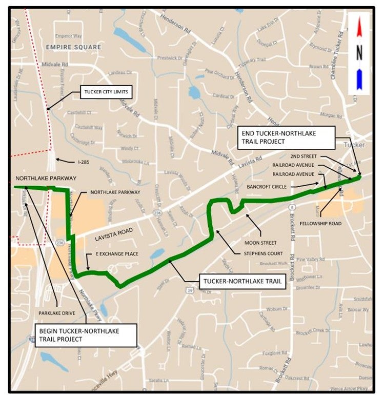
This project will build a multi-use trail network connection between downtown Tucker and the Northlake Mall area. The trail begins downtown, where it will transition to a trail bridge over Fellowship Road. The trail bridge will be outside the right-of-way of the CSX railroad but parallel to the railroad bridge. After the trail bridges over Fellowship Road, it will transition into a neighborhood greenway along Railroad Avenue.
The trail will cross Brockett Road at the signalized intersection and continue running parallel to the northern edge of the industrial properties adjacent to the existing single family residential neighborhoods along Moon Street and Stephens Court. At the end of the Stephens Court industrial area, the greenway will follow parallel the north side of the CSX active railroad right-of-way through the Oglethorpe Power Corporation campus with a side path connection along E. Exchange Place to Northlake Parkway.
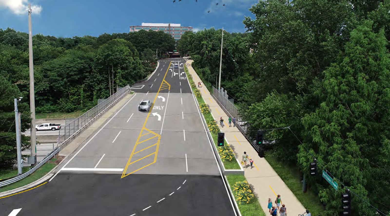
The side path will continue north on the east side of Northlake Pkwy, crossing over LaVista Road with the signalized intersection and then transition to be on the existing wide sidewalk until it reaches to the northern end of the street. On the road bridge over I-285, the Tucker PATH will follow the south side of Northlake Pkwy to Northlake Mall as a side path with roadway modification.
Objectives:
Create a multi-model path connection from Downtown Tucker to Northlake Mall
PUBLIC PRESENTATIONS/COMMUNITY ENGAGEMENT:
- Input and recommendations provided through the City’s 2019 Trail Master Plan and a Public Information Open House.
- Public Information Open House – Tucker-Northlake Trail
Tuesday August 13, 2024 | 6-7:30 p.m.
TIMELINE:
- 2024 – Undergoing design process.
PUBLIC PRESENTATIONS/COMMUNITY ENGAGEMENT:
- Input and recommendations provided through the City’s 2019 Trail Master Plan and a Public Information Open House.
- Public Information Open House – Tucker-Northlake Trail
Tuesday August 13, 2024 | 6-7:30 p.m.
TIMELINE:
2024 – Undergoing design process.
Why are we here and what is the issue we are seeking to address within our community?
The City of Tucker in conjunction with the Georgia Department of Transportation (GDOT) is seeking feedback about a proposed solution to improve bicycle and pedestrian facilities from Northlake Mall to an existing shared-use path near downtown Tucker. The Tucker-Northlake Trail from downtown Tucker to Northlake Mall project, identified as the Tucker-Northlake Trail project, is approximately 2.8 miles in length and would provide an efficient, off-road, alternate transportation for pedestrians and cyclists who traditionally travel the parallel roads, Lawrenceville Highway/State Route (SR) 8, Lavista Road/SR 236, and I-285.
What are the current conditions along the Tucker-Northlake Trail Corridor?
The proposed project corridor consists of existing major collector urban streets, existing local roads and streets, and undeveloped, wooded land between commercial, industrial, and residential buildings. The existing sidewalk coverage in the study area is not complete and bicycle lanes are absent. Adjacent roadways vary from 2 lanes (Moon Street, Bancroft Circle, Railroad Avenue, and 2nd Street) to 4 to 5 lanes with turning lanes and auxiliary lanes (East Exchange Place, Northlake Parkway Northeast and Northlake Parkway).
What happens without this project (No Build)?
- Does not design and construct the Tucker-Northlake Trail
- Does not achieve the vision identified by the City of Tucker and leaves the Tucker PATH Trail Masterplan incomplete.
- The lack of shared-use path would not be addressed along the corridor; shared-use paths increase pedestrian safety.
What is the proposed solution?
In order to improve pedestrian and bicycle safety and connectivity, the City of Tucker proposes to construct a 10’ wide, concrete shared-use path approximately 2.8 miles in length. The proposed path begins at Northlake Mall on Northlake Parkway and ends in downtown Tucker at the existing shared-use path at 2nd Street. The path consists of shared-use side paths along roadways, independent path alignments, multiple walls to reduce impacts, a boardwalk section, and a prefabricated pedestrian bridge. The construction of this entire path will require the acquisition of right-of-way and easement.
What are the benefits of project Implementation?
- Constructs the Tucker-Northlake Trail.
- Achieves the vision identified by the City of Tucker and constructs another segment of the Tucker PATH Trail Masterplan.
- Add shared-use path for bike and walkability including safety enhancements for those walking or biking.
Where is this project in the process?
This project is currently in the preliminary design phase. The preliminary design phase continues to develop proposed solutions that will meet the community’s needs that are identified in the approved concept report.
What are the Next Steps?
After the public meeting is held, feedback will be assessed, revisions may occur to the proposed plan initially brought to the public or the no build alternative will be selected. If major changes occur to what was previously shown to the community, additional public outreach would occur. If no major changes are proposed, the project would advance to right-of-way acquisition and into final design. After all right-of-way acquisition occurs, project design is finalized, and the project would advance to construction.
How can you assist and provide feedback?
Please provide feedback about our proposed solution as well as information about any resources important to you or to the community. Your feedback is important!
Questions and comments provided to the City via the Public Information Open House were summarized and are displayed below.
Thank you for your feedback. Should you have further questions or comments, please contact our City Engineer, Ken Hildebrandt at khildebrandt@tuckerga.gov.
Comments were received in support of the project and stated how the proposed trail would provide much needed recreational opportunities for families and children and connectivity for residential areas.
Thank you for your support of the project and recognition of the need for community improvements for the City.
Comments were received expressing concern that the alignment would remove too many trees, and concerns about impacts from the project to the floodplains, wetlands, and streams.
The alignment for the trail through wooded areas has been designed to avoid as many trees as possible to minimize the number of trees to be cleared. Similarly, the alignment was selected to avoid floodplains, wetlands and streams as much as possible. Where floodplains and wetlands could not be avoided, trail design would include building the trail on elevated boardwalk to allow wetland and floodplain systems to continue to function. Streams are clear-spanned with boardwalk or pedestrian bridges to avoid impacts. Where impacts to streams and wetlands cannot be avoided, permits in compliance with Section 404 of the Clean Water Act will be obtained from the US Army Corps of Engineers, and appropriate compensatory mitigation purchased when required.
Comments were received about impacts to private property and use of imminent domain to take land from private citizens for construction of the project.
Landowners whose property is needed for construction of the project would be offered fair market value for use of their property for ROW or easement. These discussions cannot begin until after approval of the environmental document. The trail has been designed to minimize the amount of private property needed for construction.
Comments were received with concerns about the safety of trail users, that the trail would lead to an increase in crime, as well as an increase in homeless encampments.
City law enforcement agencies will be responsible for patrolling the trail and providing public safety. The trail will be posted for use only between dawn and dusk, and other amenities will be included in the design to further enhance safety for users of the trail and area properties,such as lighting and emergency call boxes.
Comments were received expressing safety concerns with construction of the trail close to the railroad, while other comments were received that wanted the trail constructed along the railroad to minimize the use of private property for the project.
The trail alignment is positioned outside the railroad right-of-way (ROW) and beyond the clear zone distance required for railroad safety clearance. A fence was considered between the trail and the railroad track, but this would require a bigger project footprint, requiring acquisition of additional private property to construct. Conversely the railroad will not deed nor sell areas within their ROW for construction of a pedestrian facility for safety reasons.
Comments were received that this project would lead to increased property taxes.
There is no absolute correlation between construction of multi-use trails and an increase in property taxes. Many factors may affect an increase in property taxes and can include the location of the project in the region of the US, local economic conditions, and demographics. Often, property values increase with proximity of properties near multi-use trails.
Comments were received stating this is a waste of taxpayer money and it should be spent in other effective ways.
This project has been included in the City’s master plan, and the City has identified funding sources that are particular to this type of project. Multi-use trails offer additional recreational amenities for citizens and are popular projects to provide alternatives to use of sidewalks. Funding for this project is not being reallocated from other transportation projects such as intersection improvement projects, signal upgrades, and road improvement projects.
Several comments were received that indicated vegetation would be removed that has provided visual or noise barriers to residences, and that trail construction would remove gardens, trees, and vegetation that has been planted by private citizens.
The City understands the importance of protecting and retaining as much vegetation, gardens, trees, etc… as possible. Additionally, landscaping design will be incorporated into the project to mitigate impacts and replant vegetation where feasible.
There were comments received expressing concern about the proximity of the trail to busy roads such as Lavista Road and Northlake Parkway.
There will be separation of the trail from the back of curb and gutter along Lavista Road and Northlake Parkway. In most cases the separation will be 2-3 foot grass strip.
Comments were received asking about connectivity of the trail to residential neighborhoods (Midvale area, Winding Woods, Flowers Drive), and to extend the trail to connect with the existing PATH Foundation Stone Mountain Trail.
At the present time there is no plan to provide connection from Lavista Road to the proposed trail, except along Northlake Parkway. Residents living in areas along and that connect to Lavista Road can use the existing sidewalk network on both sides of the road to access the trail on Northlake Parkway. Connecting to the existing PATH Stone Mountain trail is not currently planned for this trail project, given that the closest point of that trail to the proposed Tucker-Northlake Trail is approximately two miles south of the proposed alignment.
There were comments received relating to the design of amenities such as pedestrian lighting and benches, and coordination with the city’s branding project.
Pedestrian lighting would be angled downward toward the trail to minimize light reflection into residential properties. Benches would be designed with a central bar. Signage and wayfaring for the trail would be consistent with the City of Tucker’s adopted color and branding scheme.
There were comments that proposed an alternative route for the trail along Lavista and Lawrenceville Highway that would result in lower impacts to citizens and the environment.
In addition to the trail connecting residential areas to public amenities, shops, and restaurants the purpose of the trail is to provide an enjoyable user experience. While some sections of the trail are located along busy roads, where possible the alignment of the trail was selected to provide a peaceful setting in undeveloped areas. There is already an existing sidewalk network along Northlake Parkway that will be improved with this project, or used in conjunction with the trail to provide connectivity.
Comments were received requesting to advertise these meetings better, and at the meeting provide more clarity on cost and schedule.
Advertisements for this meeting were posted on all of the City’s social media platforms, as well as this City website. Additionally, flyer invitations were sent to all property owners located along the project corridor. Project and city representatives were available during the in-person meeting to answer questions on cost and schedule. The current project cost is approximately $26 million dollars for design, ROW, and construction. Acquisition of ROW is anticipated to begin in 2026, with construction in 2028.